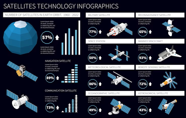
Satellites: Humanity’s Eyes Guiding Communication, Navigation, Science, and Global Progress
Satellites are among humanity’s most elegant achievements, silent strategists gliding above Earth, transforming space into a platform of possibility. Suspended in precise orbits, satellites extend human capability far beyond physical borders, acting as messengers, observers, navigators, and guardians. They translate invisible signals into everyday convenience, convert distant views into actionable intelligence, and compress the vastness of space into usable insight. From guiding a smartphone map to predicting a cyclone’s path, satellites operate as an invisible infrastructure powering modern civilization.
They don’t merely circle the planet; they synchronize global systems, enabling communication, security, science, and sustainability to operate at a planetary scale. Each satellite is engineered with intent, designed for a specific mission, placed in a calculated orbit, and powered by solar resilience. Together, they form a collaborative ecosystem above us, working in quiet harmony while life below accelerates. In essence, satellites are not just machines in space; they are strategic partners in humanity’s progress, bridging Earth and orbit with precision, purpose, and poetic efficiency.
Communication Satellites Network
Communication satellites function as high-altitude relay stations, positioned mainly in geostationary or low Earth orbits. They receive signals from Earth-based transmitters, amplify them, and retransmit them back across vast distances. This bypasses geographical barriers, such as oceans, mountains, and borders. By maintaining a fixed or predictable position relative to Earth, they ensure consistent connectivity. These satellites use transponders to handle multiple signals simultaneously, enabling seamless global information flow. Their design prioritizes signal clarity, coverage area, and uninterrupted uptime, making them foundational to the digital economy.
Key Uses
- Enable international television broadcasting by transmitting signals instantly across continents, ensuring real-time media distribution at a global operational scale.
- Support mobile and internet connectivity in remote or underserved regions where terrestrial infrastructure is economically or physically impractical.
- Power secure communication channels for governments, enterprises, and emergency services during critical operations and disaster-response scenarios.
Weather Monitoring Satellites
Weather satellites are strategic observers, continuously scanning Earth’s atmosphere from space. Positioned in polar or geostationary orbits, they track cloud movement, temperature patterns, humidity, and storm systems. Using infrared and visible sensors, they collect real-time atmospheric data that feeds forecasting models. These satellites don’t predict weather alone; they provide the raw intelligence that meteorologists translate into actionable forecasts. Their persistent monitoring enables the early detection of cyclones, heatwaves, and monsoon shifts, transforming uncertainty into preparedness.
Key Uses
- Enable early warning systems for cyclones, floods, and storms, significantly reducing human and economic losses through timely evacuation planning.
- Support climate research by recording long-term atmospheric trends, helping policymakers understand global warming and shifting weather behaviors.
- Assist the agriculture and aviation sectors by delivering precise weather intelligence that improves planning, safety, and operational efficiency.
Navigation and Positioning Satellites
Navigation satellites operate as cosmic reference points, broadcasting precise time and location signals to receivers on Earth. Systems like GPS rely on constellations of satellites working in synchronized harmony. A receiver calculates its exact position by measuring signal delays from multiple satellites simultaneously. Atomic clocks onboard ensure nanosecond-level accuracy. This invisible choreography enables pinpoint navigation anywhere on the planet, regardless of terrain or weather, making location intelligence universally accessible.
Key Uses
- Guide everyday navigation for smartphones, vehicles, ships, and aircraft with real-time positioning and route optimization capabilities.
- Enable precision agriculture by supporting automated farming equipment, improving yield efficiency and reducing resource wastage.
- Power critical infrastructure timing for financial networks, power grids, and telecommunications systems requires ultra-precise synchronization.
Earth Observation Satellites
Earth observation satellites act as analytical mirrors, capturing high-resolution images and data about Earth’s surface. Equipped with optical, radar, and multispectral sensors, they observe land, oceans, and ecosystems regardless of daylight or weather conditions. Their data reveals patterns invisible to the human eye, deforestation trends, urban expansion, water stress, and environmental degradation. These satellites convert visual intelligence into strategic insight for sustainable decision-making.
Key Uses
- Monitor environmental changes like deforestation, glacier retreat, and coastal erosion to support conservation and sustainability initiatives.
- Assist urban planning by providing accurate land-use data for smarter infrastructure development and population management.
- Support disaster assessment by rapidly mapping affected areas after earthquakes, floods, or fires to accelerate relief operations.
Scientific Research Satellites
Scientific satellites are curiosity-driven explorers, designed to study space, Earth, and the universe beyond. They operate above atmospheric interference, allowing pure observation of cosmic phenomena. Some study solar radiation, others analyze cosmic rays, magnetic fields, or distant galaxies. These satellites carry specialized instruments tailored for focused research missions. Their findings expand human knowledge, refine scientific models, and often lead to technologies that later benefit everyday life.
Key Uses
- Advance space science by studying stars, planets, and cosmic events, deepening our understanding of the universe’s origins.
- Observe Earth’s magnetic field and radiation belts, improving spacecraft safety and space-weather forecasting accuracy.
- Drive innovation by generating scientific discoveries that influence materials science, medicine, and advanced engineering applications.
Military and Defense Satellites
Defense satellites operate with strategic discretion, supporting national security from orbit. They provide surveillance, reconnaissance, secure communication, and missile detection capabilities. Using high-resolution imaging and signal intelligence tools, they monitor global activities in near real time. Their elevated vantage point ensures persistent awareness without physical presence, making them force multipliers rather than frontline assets.
Key Uses
- Enable real-time surveillance and intelligence gathering to support informed defense and geopolitical decision-making.
- Provide secure, encrypted communication channels for military operations across land, sea, air, and space domains.
- Detect missile launches early, strengthening national defense systems and reducing response time during critical threats.
Satellites are not merely technological artifacts; they are strategic enablers shaping how humanity communicates, navigates, predicts, protects, and explores. Quietly orbiting above, they orchestrate a symphony of data that keeps our world aligned, informed, and future-ready.